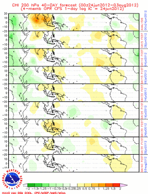
The forecast off the CFS of the MJO is looking like we may see some activity by Africa. Enhanced convection appears to be in the works in that region in the next couple weeks, with another bout of storminess by late July. The MJO should support low opportunities for tropical cyclone formation in the East Pacific in the next few weeks, and this could continue into August.
The movement of this convection shows me that the MJO should stay within Phases 8-3 for a while as dry conditions stay farther towards Asia, and enhanced convection appears in the Atlantic. However, getting into July, we see dry conditions spread east, signaling a progressing MJO into the middle phases.
So what does all of this mean? I am expecting potentially another opportunity for tropical development in the eastern Atlantic as the MJO favors enhanced convection in that area. Additionally, there should be below normal thunderstorm activity in the Eastern Pacific due to unfavorable upper level winds.
Andrew


No comments:
Post a Comment