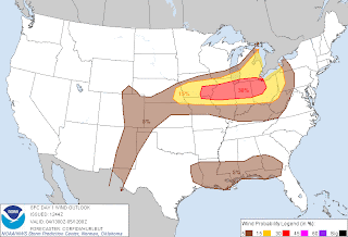
Slight Risk area (Lower and East Great Lakes into Central/Upper Plains...
A cold front currently extends from Central Wisconsin SW into Central Iowa and into Kansas. This cold front is connected to a low pressure system currently located in Southwest Kansas. Just out ahead of the cold front is a warm front. This warm front reaches from the west border of Lake Michigan vertically down through East Illinois. Both of these fronts eventually connect into an occluded front in the Upper portion of Michigan (not the 'glove').
All of this is related to a very intense low pressure system in Canada. This intense low will move east and drag along the fronts. However, the much weaker low earlier mentioned in southwest Kansas will remain stationary. As a result, the cold front connected to that now stationary low will flatten out horizontally across the US. This will create the scene for severe weather.
The short range model RUC displays the cold front moving through with showers and embedded thunderstorms. However, the RUC puts out a small line of intense thunderstorms affecting Northeast Illinois only. A very localized string of strong/severe storms. This small line would be forecast to reach Northeast Illinois at 3pm CDT as of the latest forecast.
The Rapid Refresh short range model is also on board with this solution but may be slightly faster, with the storms possibly already impacting the area by 3pm CDT.
The main concern with these storms will be damaging winds and hail. The tornado threat is actually very low at this point, and I will disregard that concern for tornadoes. However, it does look like damaging winds is a good bet along with hail for primary threats.
 |
| Today's Hail threat |
 |
| Today's damaging wind threat |
 |
| Today's Tornado threat |


No comments:
Post a Comment